


Atmosphere 2023, 14(9), 1382; https://doi.org/10.3390/atmos14091382 (registering DOI) - 31 Aug 2023
Abstract
From December 2021 to May 2022, MeteoSwiss and Meteomatics conducted a proof of concept to demonstrate the capability of automatic drones to provide data of sufficient quality and reliability on a routine operational basis. Over 6 months, Meteodrones MM-670 were operated automatically eight
[...] Read more.
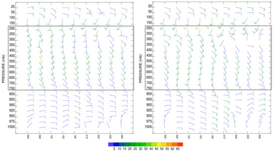
From December 2021 to May 2022, MeteoSwiss and Meteomatics conducted a proof of concept to demonstrate the capability of automatic drones to provide data of sufficient quality and reliability on a routine operational basis. Over 6 months, Meteodrones MM-670 were operated automatically eight times per night at Payerne, Switzerland. In total, 864 meteorological profiles were measured and compared to co-located standard measurements, including radiosoundings and remote sensing instruments. To our knowledge, this is the first time that Meteodrone’s atmospheric profiles have been evaluated in such an extensive campaign. The paper highlights two case studies that showcase the performance and challenges of measuring temperature, humidity, and wind with a Meteodrone. It also focuses on the overall quality of the drone measurements. Throughout the campaign, the availability of Meteodrone measurements was 75.7%, with 82.2% of the flights reaching the nominal altitude of 2000 m above sea level. The quality of the measurements was assessed against the WMO’s (World Meteorological Organization) requirements. The temperature measurements gathered by the Meteodrone met the “breakthrough” target, while the humidity and wind profiles met the “threshold” target for high-resolution numerical weather prediction. The temperature measurement quality was comparable to that of a microwave radiometer, and the humidity quality was similar to that obtained from a Raman LiDAR. However, the wind measurements gathered by a Doppler LiDAR were more accurate than the estimation provided by the Meteodrone. This campaign marks a significant step towards the operational use of automatic drones for meteorological applications.
Full article
(This article belongs to the Special Issue Unmanned Aerial Systems for Investigating the Troposphere: Developments and Applications)


