


Land 2023, 12(9), 1711; https://doi.org/10.3390/land12091711 (registering DOI) - 01 Sep 2023
Abstract
Farmland pollution severely threatens humanity’s sustainable development. Exploring farmland quality protection behavior (FQPB) from the farmers’ perspective is considered one of the best ways to solve the farmland pollution problem. This study develops a theoretical framework for farmers’ FQPB from the perspectives of
[...] Read more.
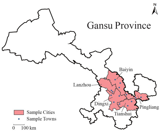
Farmland pollution severely threatens humanity’s sustainable development. Exploring farmland quality protection behavior (FQPB) from the farmers’ perspective is considered one of the best ways to solve the farmland pollution problem. This study develops a theoretical framework for farmers’ FQPB from the perspectives of place attachment (consisting of place identity, dependency, and affection) and self-efficacy. We conducted a primary survey of 412 corn farmers from the northwestern Chinese province of Gansu and empirically examined the effects of place attachment and self-efficacy on farmers’ FQPB and verified the moderating effects that self-efficacy exerts on the influence of place attachment on FQPB by using hierarchical regression and propensity score matching models. The results indicate that: (1) among the three dimensions of place attachment, farmers with stronger place identity and place affection are more likely to implement FQPB; conversely, farmers who exhibit stronger place dependency are less likely to engage FQPB; and (2) self-efficacy not only effectively promotes farmers’ FQPB but also has an enhancing effect on the influence of place identity and place affection on FQPB. Our results suggest that policymakers should encourage farmers to maintain a place’s image and guide farmers to participate in place construction; thus, farmers’ place identity and place affection can be fostered. Meanwhile, the government should diversify the income sources of farmers to reduce their dependency on a single source. The finding that self-efficacy effectively promotes FQPB also implied that the formulation of farmland quality protection policies should shift from traditional command-based policies to participatory approaches, utilizing the initiative of farmers to enhance the policy’s effectiveness, which can not only promote farmers’ FQPB through self-efficacy but also strengthen the positive influence of place identity and place affection on FQPB.
Full article
(This article belongs to the Section Land Socio-Economic and Political Issues)
►
Show Figures
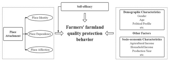
Figure 1


